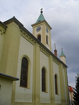
Lutheran Church
Lutheran Church
Original function:
church
Current function:
church
Church:
Lutheran
Settlement:
Address:
Hlavná 300, 929 01 Dunajská Streda
Historical Hungarian county:
Pozsony
Country:
Slovakia
GPS coordinates:
47.994203, 17.617192
Google map:
Useful links
csemadok.sk
History
It was built between 1863 and 1883 in neo-Romanesque style. The tower was added in 1938.
Source: csemadok.sk
Check out other sights in Dunaszerdahely as well!
Show on Google map
© OpenStreetMap contributors
{"item":"sight","set":{"sightId":473,"townId":26,"active":1,"name_LO":"","address":"Hlavn\u00e1 300, 929 01 Dunajsk\u00e1 Streda","mapdata":"1|439|601","gps_lat":"47.9942030000","gps_long":"17.6171920000","religion":3,"oldtype":"1","newtype":"1","homepage":"","openinghours":"","muemlekemlink":"","csemadoklink":"http:\/\/emlekhelyek.csemadok.sk\/emlekhelyek\/evangelikus-templom\/\r","picture":"\u003Ca title=\u0022Szeder L\u00e1szl\u00f3 \/ CC BY-SA (https:\/\/creativecommons.org\/licenses\/by-sa\/4.0)\u0022 href=\u0022https:\/\/commons.wikimedia.org\/wiki\/File:Dunaszerdahely066.JPG\u0022\u003E\u003Cimg width=\u0022256\u0022 alt=\u0022Dunaszerdahely066\u0022 src=\u0022https:\/\/upload.wikimedia.org\/wikipedia\/commons\/thumb\/e\/ec\/Dunaszerdahely066.JPG\/256px-Dunaszerdahely066.JPG\u0022\u003E\u003C\/a\u003E","picture_ref":"\u003Ca href=\u0022https:\/\/commons.wikimedia.org\/wiki\/File:Dunaszerdahely066.JPG\u0022 title=\u0022via Wikimedia Commons\u0022\u003ESzeder L\u00e1szl\u00f3\u003C\/a\u003E \/ \u003Ca href=\u0022https:\/\/creativecommons.org\/licenses\/by-sa\/4.0\u0022\u003ECC BY-SA\u003C\/a\u003E","name":"Lutheran Church ","note":"","history":"It was built between 1863 and 1883 in neo-Romanesque style. The tower was added in 1938.","town":{"townId":26,"name_HU":"Dunaszerdahely","name_LO":"Dunajsk\u00e1 Streda","seolink":"dunaszerdahely-dunajska-streda","oldcounty":1,"country":2}},"language":"en","region":"slovakia","regionid":2,"offer":[],"gallery":false,"album":false}

