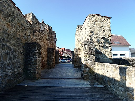
Lower Gate and Stone Bridge
Dolná brána
Lower Gate and Stone Bridge
Dolná brána
Original function:
town gate
Current function:
town gate
Historical Hungarian county:
Sáros
GPS coordinates:
49.294106, 21.27881
History
The fortifications of the town were built after the Mongol Invasion. It had four gates, which opened to the south, west, north and northeast. The plain of the town slightly slopes north, so the southern gate, which was located on the highest point, was called Upper Gate, while the northeastern gate, which was located on the lowest point, was called Lower Gate. The walls were defended by wide moats.
The trade road coming from the central regions of Hungary left the town towards Poland through the Lower Gate. From the town gate a little wooden bridge led to a half-round barbican, which still stands, surrounded by moats. From the barbican a drawbridge led across the moat. After the fortifications of the town lost their significance, the wooden bridges over the moats were demolished and a new stone bridge was raised with two 5-metres wide arches in 1821. A similar stone bridge was built to connect the barbican with the town but it had only one arch.
{"item":"sight","set":{"sightId":209,"townId":15,"active":1,"name_LO":"Doln\u00e1 br\u00e1na","address":"","mapdata":"1|1320|123","gps_lat":"49.2941060000","gps_long":"21.2788100000","religion":0,"oldtype":"23","newtype":"23","homepage":"","openinghours":"","muemlekemlink":"https:\/\/www.muemlekem.hu\/hatareset\/Also-kapu-kohidja-Bartfa-3473","csemadoklink":"\r","picture":"\u003Ca title=\u0022Photograph: palickap \/ CC BY-SA (https:\/\/creativecommons.org\/licenses\/by-sa\/4.0)\u0022 href=\u0022https:\/\/commons.wikimedia.org\/wiki\/File:Bardejov,_Doln%C3%A1_br%C3%A1na_(4).JPG\u0022\u003E\u003Cimg width=\u0022512\u0022 alt=\u0022Bardejov, Doln\u00e1 br\u00e1na (4)\u0022 src=\u0022https:\/\/upload.wikimedia.org\/wikipedia\/commons\/thumb\/d\/d3\/Bardejov%2C_Doln%C3%A1_br%C3%A1na_%284%29.JPG\/512px-Bardejov%2C_Doln%C3%A1_br%C3%A1na_%284%29.JPG\u0022\u003E\u003C\/a\u003E","picture_ref":"\u003Ca href=\u0022https:\/\/commons.wikimedia.org\/wiki\/File:Bardejov,_Doln%C3%A1_br%C3%A1na_(4).JPG\u0022 title=\u0022via Wikimedia Commons\u0022\u003EPhotograph: palickap\u003C\/a\u003E \/ \u003Ca href=\u0022https:\/\/creativecommons.org\/licenses\/by-sa\/4.0\u0022\u003ECC BY-SA\u003C\/a\u003E","name":"Lower Gate and Stone Bridge ","note":"","history":"The fortifications of the town were built after the Mongol Invasion. It had four gates, which opened to the south, west, north and northeast. The plain of the town slightly slopes north, so the southern gate, which was located on the highest point, was called Upper Gate, while the northeastern gate, which was located on the lowest point, was called Lower Gate. The walls were defended by wide moats.@The trade road coming from the central regions of Hungary left the town towards Poland through the Lower Gate. From the town gate a little wooden bridge led to a half-round barbican, which still stands, surrounded by moats. From the barbican a drawbridge led across the moat. After the fortifications of the town lost their significance, the wooden bridges over the moats were demolished and a new stone bridge was raised with two 5-metres wide arches in 1821. A similar stone bridge was built to connect the barbican with the town but it had only one arch.","town":{"townId":15,"name_HU":"B\u00e1rtfa","name_LO":"Bardejov","seolink":"bartfa-bardejov","oldcounty":17,"country":2}},"language":"en","region":"slovakia","regionid":2,"offer":[],"gallery":false,"album":false}

